
30 Day Map Challenge - November 2023
Published:
All maps are made with open source software and open data. Data cleaning and wrangling done in R with visuals produced in QGIS.
DAY 1 - POINTS
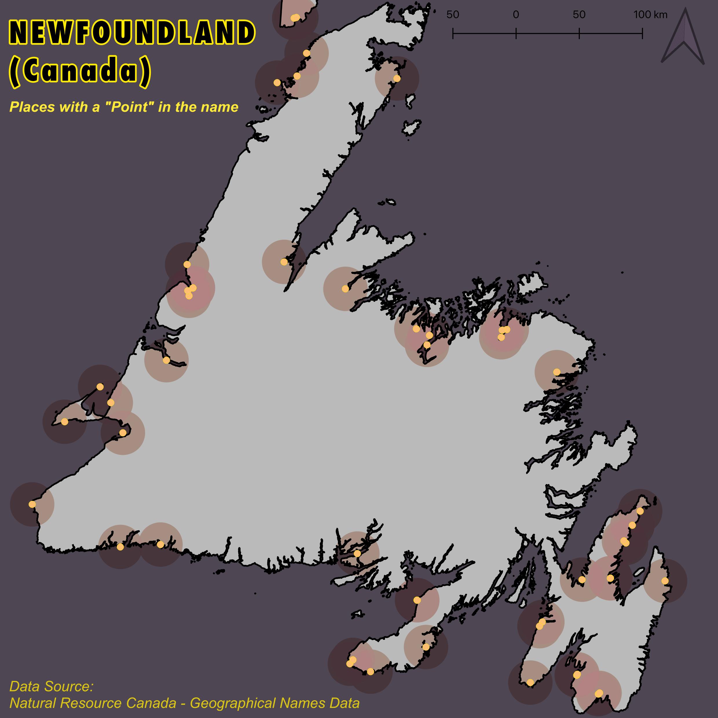
Points: Here, we have a map of all populated places on the island of Newfoundland which have "Point" in their name. While not an inhabited settlement, and not shown here, by far the most famous 'Point' is likely to be Mistaken Point (Furthest Cape to the South-East). Here, for many years, sailors were often fatally mistaken in their navigation due to weather and visibility. Thinking they had made it to the inhabited and navigable Cape Race, they would turn northwards and straight into the fog-masked cliffs. Mistaken Point is home to the worlds oldest fossils of complex organisms and about 600 km away from the Titanic's final resting place, being the receiver of the distress call.
DAY 2 - LINES
Lines: The Trans-Canada Highway is one of the lifelines of the country, linking the east and west coast across approx. 7,500 km. Work on the route started around 1950, with the main road spanning all ten provinces and 905 km in Newfoundland itself. Probably the most well known sentiment many Canadians have with the TCH relates to Terry Fox's Marathon of Hope. In April 1980, he first dipped his prosthetic leg off the St. John's coast at Mile 0 and ran his way across Canada, changing the face of Cancer research and lives everywhere.

DAY 3 - POLYGONS

Polygons: The ever important Moose Management Areas of Newfoundland. Originally not native to the island, four moose were brought to Newfoundland in 1904 and they’ve since exploded on the scene with over 120,000 in number now. They can be a bit daft, wandering onto the roads and into cities to eat what they can find and lick the road salt in the winter. Newfoundland has some of the highest density of moose around, and vehicle collisions are a major issue in the province with around 600 accidents a year, often fatal. Lots of resources and interventions go into moose management as seen by the Gov. NL 2022-26 Moose Management Plan.
DAY 4 - BAD MAP
Bad Map: Bad Map. Phoning today in a bit, but hear me out… here’s a wonderful map - really lots of great information. But unfortunately I’ve made some very BAD colour design choices. Hard to see much when your map fill and borders match the background colour! Goes to show the importance of colour, contrast and design decisions for knowledge exchange and teaching.

DAY 5 - ANALOG MAP

Analog: Here we have Newfoundland etched in stone at the Padrão dos Descobrimentos in Lisbon, Portugal. This massive *mappa mundi* is directly in front of the monument dedicated to the 15th/16th-c. Golden Age of Discoveries. The stone monument was erected in 1960 with the square out front and map given by the South African Government. The whole complex features rare lioz (royal) Lisbon limestone, and rose-tinted stone from Leiria.
DAY 6 - ASIA
Asia: Ten years ago I took a field trip to China during my masters at Nova School of Business and Econ. hosted at Sun Yat-sen Uni. I originally wanted to be a labour economist until I saw the scale of urban development going on here.

DAY 7 - NAVIGATION

Navigation: Lighthouses have dotted our coastline since 1813 with the first lighthouse guiding ships from Fort Amherst through The Narrows. As a historic maritime economy, these built structures were crucial. 44 lighthouses were built from 1832-1890. Today, many of these lighthouses are historic museums and built heritage standing tall on cliffs and capes. While often not functioning in the maritime sense, they still provide easy navigation and bearings for seafaring folk and landlubbers alike.
DAY 8 - AFRICA
Africa: This year I was so lucky to start a great project on flood and water management in Quelimane, Mozambique. Lots of participatory GIS and community-focused interventions. Here we have the elevation and watercourses of the Zambezia province for the 30 day map challenge. This area is particularly vulnerable to flooding and effects of climate change. Our project is looking at feasible community interventions locals can realistically adopt to mitigate against hazards. Project ongoing with @sleeffers, @patscaetano and @novafrica!

DAY 9 - HEXAGONS

Hexagons: Taking this one into the office today. Of course with hexagons, the first thing I now think of is our (un-sarcastically) beautiful brutalist hexagonal office building - home to the Department of Urban Studies and Planning and the Department of Geography. Built around 1970-71, the building is a series of interlocking hexagons - we knew hex spatial geometries would be cool for GIS long ago!
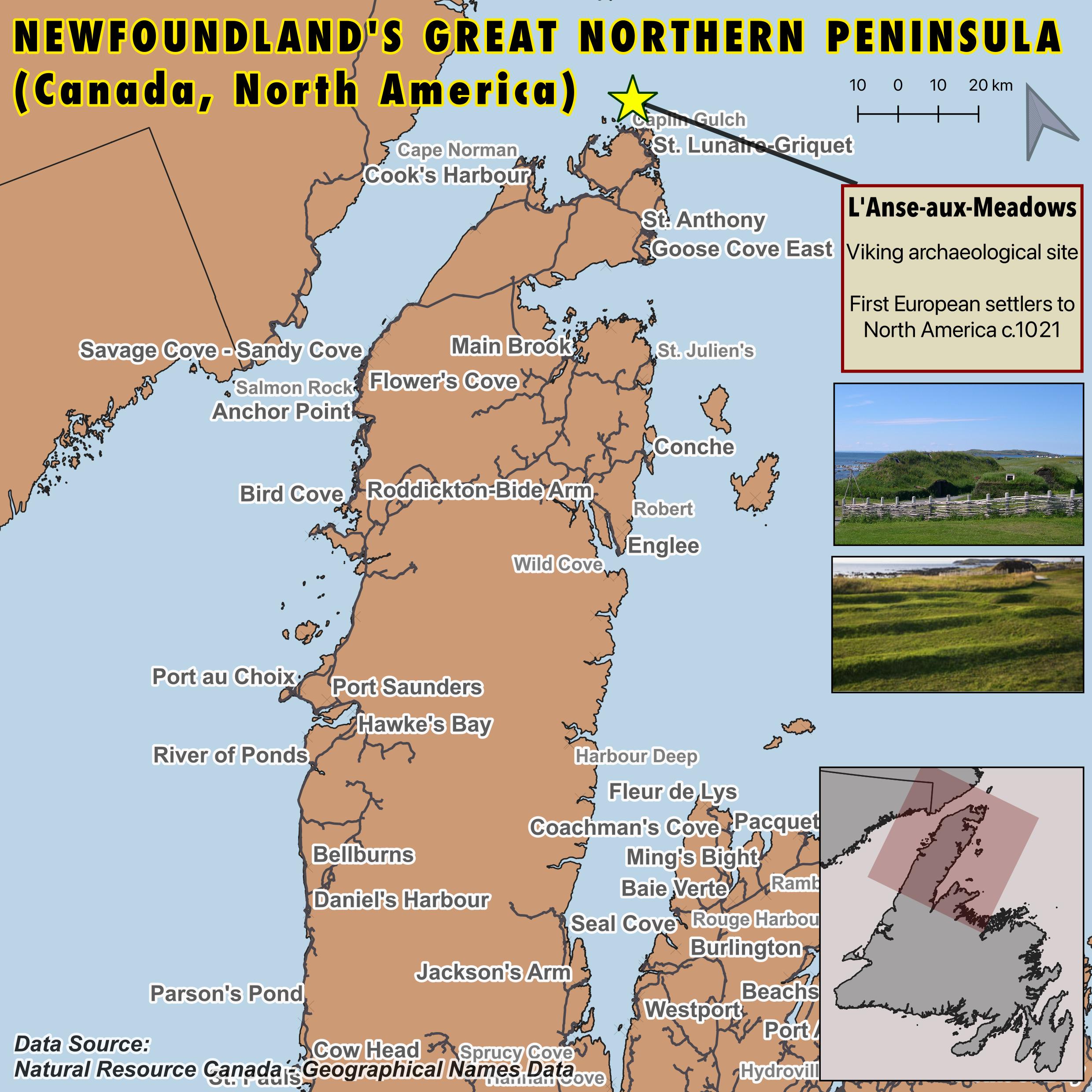
DAY 10 - NORTH AMERICA
North America: The earliest confirmed European settlers to North America came around 1021 in L’Anse-Aux-Meadows at the tip of NL’s Great Northern Peninsula. Vikings were in North America well before Columbus sailed the ocean blue. All Newfoundlanders I’m sure can recite “In 1492 Columbus sailed the ocean blue, in 1497 John Cabot discovered heaven (aka. NL)” — but I suppose this needs updating… “in 1021, Leif Erickson followed the sun?…. discovered the fun?”… not quite the same ring. The archaeological site was first discovered around 1960. But Vikings were just the European settlers, and the area was active for thousands of year before with indigenous populations, most notably the Dorset people around 500 years before the Vikings.️
Jacob L. Macdonald